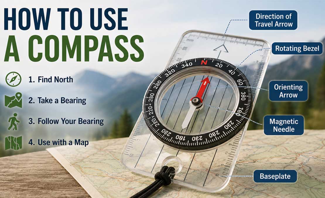
how to use a compass.
How to Use a Compass: A Complete Step-by-Step Guide
Learning how to use a compass is an important navigation skill for hiking, camping, backpacking, orienteering, and outdoor travel. A compass can help you determine direction, take a bearing, follow a route, and work with a map even when you cannot rely on a phone or GPS device.
This guide explains how to use a compass from the basics to practical navigation techniques. You will learn how to identify the parts of a compass, find north, take and follow bearings, orient a map, understand magnetic declination, and avoid common navigation mistakes.
What Is a Compass?
A compass is a navigation instrument that uses Earth's magnetic field to indicate magnetic direction. The magnetic needle aligns with the local magnetic field, giving you a reference for magnetic north.
Unlike a smartphone, a traditional magnetic compass does not need batteries or a mobile signal. This makes it a useful backup navigation tool when hiking or traveling in areas where electronic devices may fail.
Understanding the Main Compass Directions
The four primary compass directions are north, south, east, and west. Between these are the intermediate directions northeast, southeast, southwest, and northwest.
A compass can also provide a direction as a bearing measured in degrees. Bearings normally range from 0 to 360 degrees.
- North: 0° or 360°
- East: 90°
- South: 180°
- West: 270°
For example, a bearing of 45° represents northeast, while 315° represents northwest.
Parts of a Baseplate Compass
Before learning how to use a compass, it helps to understand its main parts. A typical baseplate compass contains several important components.
Magnetic Needle
The magnetic needle is the movable needle inside the compass. Its magnetized end aligns with the Earth's magnetic field and indicates magnetic north.
Direction-of-Travel Arrow
The direction-of-travel arrow is usually printed on the baseplate and points toward the direction you want to travel.
Rotating Bezel
The bezel is the rotating ring around the compass. It contains degree markings that allow you to set or read a bearing.
Orienting Arrow
The orienting arrow is located inside the rotating bezel. It is used to align the compass with the magnetic needle when taking or following a bearing.
Orienting Lines
Orienting lines are parallel lines inside the bezel. When using a map, these lines are aligned with the north-south grid lines on the map.
Index Line
The index line is the fixed reference point where you read the bearing after setting the compass.
Types of Compasses
There are several types of compasses, although they all provide directional information based on Earth's magnetic field.
Baseplate Compass
A baseplate compass is commonly used for hiking, map navigation, and orienteering. Its transparent base and straight edges make it particularly useful with paper maps.
Lensatic Compass
A lensatic compass is designed for more precise sighting of distant objects. It is commonly associated with military-style navigation.
Thumb Compass
A thumb compass is compact and is often used in orienteering, where the compass is held directly against a map while moving quickly.
Digital Compass
A digital compass uses electronic sensors to determine direction. Smartphones commonly include digital compass sensors, but electronic compasses depend on batteries and can be affected by nearby magnetic materials.
Magnetic North vs. True North
One of the most important concepts in compass navigation is the difference between magnetic north and true north.
True north refers to geographic north, while magnetic north is the direction indicated by a magnetic compass. The angle between these directions is called magnetic declination, also known as magnetic variation.
Magnetic declination is not the same everywhere. It varies according to geographic location and also changes gradually over time.
This matters because a map is normally referenced to geographic or grid north, while your compass responds to the Earth's magnetic field. For accurate navigation over longer distances, you need to account for the declination for your location.
What Is Magnetic Declination?
Magnetic declination is the angular difference between true north and magnetic north. It may be described as east or west declination.
For example, if a location has a magnetic declination of 10° east, magnetic north and true north differ by 10 degrees. If the declination is 10° west, the difference is in the opposite direction.
The correct declination depends on both location and date. Official geomagnetic models can be used to estimate the current declination for a specific location. NOAA's National Centers for Environmental Information provides magnetic declination calculations based on models such as the World Magnetic Model.
How to Find North With a Compass
Finding north is the first basic skill to practice with a compass.
- Move away from large metal objects, vehicles, magnets, and electronic equipment.
- Hold the compass flat and level in your hand.
- Wait for the magnetic needle to stop moving.
- Identify the end of the needle that indicates magnetic north.
- Use the compass markings to identify the remaining directions.
Keep the compass level while taking a reading. Holding it at an angle can make the needle move against the housing and make the reading less reliable.
How to Take a Compass Bearing
A bearing is a direction expressed as an angle from north. Instead of saying that a destination is roughly northeast, you can describe its direction more precisely with a bearing such as 45 degrees.
To take a bearing to a visible landmark:
- Hold the compass flat and level.
- Point the direction-of-travel arrow directly toward the landmark.
- Keep the compass pointed at the landmark.
- Rotate the bezel until the orienting arrow aligns with the magnetic needle.
- Read the degree value at the index line.
The number at the index line is the bearing toward the landmark. This basic method is also useful when you want to record the direction of a trail, mountain, building, or other identifiable feature.
What Does “Red in the Shed” Mean?
A common navigation phrase is “red in the shed.” It is a simple way to remember that when following a bearing, the north end of the magnetic needle should be aligned inside the orienting arrow on the compass.
The exact colors and markings vary between compass designs, so use the actual north indication and orienting arrow on your compass rather than relying only on the phrase.
How to Follow a Compass Bearing
Once you have a bearing, you can use it to travel in the desired direction.
- Set the required bearing on the compass bezel.
- Hold the compass level in front of you.
- Point the direction-of-travel arrow away from your body.
- Rotate your body until the magnetic needle aligns with the orienting arrow.
- Look along the direction-of-travel arrow.
- Choose a visible landmark in that direction if possible.
- Walk toward that landmark rather than constantly staring at the compass.
- Repeat the process as necessary to maintain your course.
Using intermediate landmarks can make navigation easier because you can walk toward a tree, rock, trail junction, or other identifiable feature and then take another reading.
How to Use a Compass With a Map
A compass becomes much more useful when combined with a detailed map. You can use the two together to orient yourself, determine a route, and calculate bearings between locations.
How to Orient a Map With a Compass
Orienting a map means rotating it so that the directions shown on the map correspond with the real-world directions around you.
- Place the map on a reasonably flat surface.
- Place the compass on the map with the direction-of-travel arrow pointing toward the top of the map.
- Rotate the compass bezel so its north marking corresponds to the map's north direction.
- Align the compass edge with a north-south line on the map.
- Rotate the map and compass together until the magnetic needle aligns correctly with the orienting arrow, taking the local declination into account where required.
Once the map is oriented, landmarks on the map can be compared with what you see around you. This makes it easier to understand your surroundings and plan a route.
How to Take a Bearing From a Map
You can also use a map and compass to determine the bearing from your current location to a destination.
- Identify your current location on the map.
- Identify the destination.
- Place the straight edge of the compass between your current position and the destination.
- Make sure the direction-of-travel arrow points toward the destination.
- Rotate the bezel until the orienting lines run parallel with the map's north-south lines.
- Make sure the north marking on the bezel points toward north on the map.
- Read the bearing at the index line.
You can then take the compass off the map and use that bearing in the field. The basic map-and-bearing procedure is a standard compass navigation technique.
How to Take a Bearing From a Landmark
A compass can also help you determine where you are on a map when you can identify a visible landmark.
- Find a landmark that you can clearly identify in the landscape.
- Find the same landmark on your map.
- Take a compass bearing toward the landmark.
- Transfer that bearing to the map.
- Use the known landmark and bearing to establish your position.
Using more than one identifiable landmark can provide a stronger position fix because the bearings can be compared against multiple locations on the map.
What Is a Back Bearing?
A back bearing is the opposite direction of a bearing. It can be useful when retracing a route or checking the direction from a destination back toward your starting point.
To calculate a back bearing, add 180 degrees if the original bearing is less than 180 degrees. If the original bearing is 180 degrees or greater, subtract 180 degrees.
For example:
- 45° becomes 225°
- 120° becomes 300°
- 200° becomes 20°
- 315° becomes 135°
How to Navigate in Poor Visibility
Fog, darkness, heavy rain, snow, and dense vegetation can make landmarks difficult to see. In these conditions, compass navigation becomes especially useful, but you should use additional care.
Before entering an area with poor visibility, determine your route and identify useful landmarks or checkpoints. Take regular compass readings and compare them with your map rather than relying on one direction for a long period.
If possible, use a GPS device or phone as an additional navigation aid, but do not rely exclusively on electronics for remote trips. A physical compass and map provide useful redundancy if a device loses power or stops working.
Common Compass Mistakes to Avoid
- Holding the compass at an angle: Keep the compass level while taking readings.
- Ignoring magnetic declination: Check the declination for the area when accurate map navigation is required.
- Standing near metal: Vehicles, metal equipment, magnets, and some electronic devices can interfere with magnetic readings.
- Reading the wrong end of the needle: Make sure you know which end indicates magnetic north.
- Turning the bezel incorrectly: Understand which markings and arrows belong to your particular compass.
- Walking while staring continuously at the compass: Use the compass to establish direction and then use safe, visible landmarks whenever possible.
- Using an outdated declination value: Magnetic declination changes over time, so use an appropriate current value for your location.
- Depending on only one navigation method: Carry a map and compass as backup when navigating in remote areas.
How to Practice Using a Compass
The best way to learn compass navigation is to practice in a familiar and safe area before relying on the skill in remote terrain.
Start by practicing simple tasks such as finding north, taking bearings toward nearby landmarks, and following short bearings. Then practice orienting a map and transferring bearings between the map and the landscape.
As your confidence improves, practice navigating between several checkpoints without relying continuously on your phone or GPS.
Compass Navigation Example
Imagine that you are standing at a trail junction and your campsite is located northeast of your position. Instead of simply walking in the general direction of the campsite, you can identify the campsite on your map, take a bearing, and use that bearing to guide your route.
For example, if your calculated bearing is 45 degrees, you would set the compass to 45 degrees, align the magnetic needle correctly, and travel in the direction indicated by the direction-of-travel arrow. Along the way, you can use visible landmarks and your map to confirm that you remain on the intended route.
How Accurate Is a Compass?
A magnetic compass can provide useful directional information, but accuracy depends on how it is used and the surrounding conditions. Nearby magnetic materials, incorrect handling, local magnetic-field effects, and failure to account for declination can introduce errors.
For navigation over longer distances, even a small directional error can become significant. This is why accurate bearings, appropriate map use, and correct declination handling are important.
How to Take Care of a Compass
- Keep the compass away from strong magnets.
- Avoid storing it directly next to magnetic or electronic equipment.
- Protect the compass from unnecessary impacts and scratches.
- Keep the baseplate and housing clean.
- Check the compass before an important trip.
- Replace a damaged or unreliable compass rather than depending on it for critical navigation.
Compass vs. GPS: Which Is Better?
A compass and GPS device serve different purposes, and carrying both can provide useful redundancy.
GPS can provide your position and route information quickly, while a traditional compass can provide directional reference without batteries or a satellite signal. For outdoor navigation, using a map, compass, and electronic navigation device together can provide a more robust approach than depending on only one system.
Frequently Asked Questions
Which direction does a compass point?
A magnetic compass aligns with Earth's local magnetic field and indicates magnetic north. It does not simply point to geographic true north, which is why magnetic declination matters when comparing compass readings with a map.
What is a compass bearing?
A compass bearing is a direction expressed as an angle, normally measured clockwise from north from 0 to 360 degrees.
What is magnetic declination?
Magnetic declination is the angular difference between magnetic north and true north. It varies with location and changes over time.
Can I use a compass without a map?
Yes. You can use a compass to find magnetic north, take bearings toward landmarks, and follow a bearing without a map. However, a map provides important information about terrain, routes, landmarks, and your position.
Can a phone replace a compass?
A phone can provide compass and navigation functions, but it depends on electronic sensors and battery power. For outdoor trips, a physical compass can be a useful backup.
What is the easiest way to learn compass navigation?
Start with finding north, then practice taking bearings toward visible landmarks. After that, learn how to orient a map and transfer bearings between the map and the landscape. Regular practice in a safe area is the best way to build confidence.
Final Thoughts
Learning how to use a compass takes some practice, but the basic skills are straightforward. Start by understanding the compass parts, learn how to find magnetic north, practice taking and following bearings, and then combine the compass with a map.
For more advanced navigation, learn how to handle magnetic declination, orient maps, use back bearings, identify landmarks, and confirm your position from multiple reference points. With regular practice, a compass can become a reliable part of your outdoor navigation kit.
Learn how to use a compass, take bearings, find north, and navigate.



.png)
Leave A Comment